Crabtree Creek Trail
The Crabtree Creek Trail in suburban Raleigh, North Carolina, is composed of seven segments: Alleghany, Buckeye, Crabtree Valley, Crabtree-Oak Park, Fallon Creek, Middle Crabtree Creek and North Hills. The segments range from 0.25 mile to just over 3 miles long, for a total of 19.3 miles for the whole trail system.
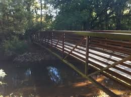
The trail system follows the Crabtree Creek corridor through forested greenways, city parks, residential areas and among some business areas.
The trail passes through stands of loblolly pine, elm, ash, buckeye, river birch and poplar with an understory of box elder, hornbeam holly and dogwood. Trail users also experience lovely views of Crabtree Creek, with large rock outcroppings here and there, as well as steep slopes. At Lassiter Mill Park you can see the former site of Lassiter Mill Dam and former site of grist mill built in 1764. The mill last operated from 1908 to 1958.
Though mostly asphalt, some portions are unpaved. You'll find picnic areas and a playground on Crabtree Blvd and plenty of wildlife viewing opportunities, especially along the boardwalk over wetlands near Raleigh Boulevard. Look for the gazebo where you can watch and photograph birds, including waterfowl and blue herons.
Parking is available at a number of locations along the trail, including Cedar Fork District Park (228 Aviation Pkwy Morrisville), North Hills Park (100 Chowan Cir, Raleigh), Kiwanis Park (2525 Noble Rd, Raleigh), Anderson Point Park (20 Anderson Point Dr, Raleigh 27610).
Type of Trail
Bicycling/Skating, Walking
Area
Downtown & West Raleigh, Brier Creek & NW Raleigh
Address
4000 Lindsay Drive
City
Raleigh
State
NC
Zip Code
27612
Telephone
E-mail
Website
Verified